Showing posts with label maps. Show all posts

Sunday, January 3, 2016

1896 Bicycle Map for DC and Area

Roberts' [bicycle] road map of the District of Columbia and adjoining portions of Maryland and Virginia.

Cover title: Bicycle road map : Roberts' road map of the District of Columbia and adjoining portions of Maryland and Virginia : with tables of distances ... character of roads.
Created / Published - Washington : W.F. Roberts, c1896
Library of Congress, Geography & Map Division
http://lccn.loc.gov/88693356

Roberts Bicycle Map Washington DC and area 1896
Click here for zoom view of this 1896 map

Roberts Bicycle Map Washington DC and area 1896 - detail
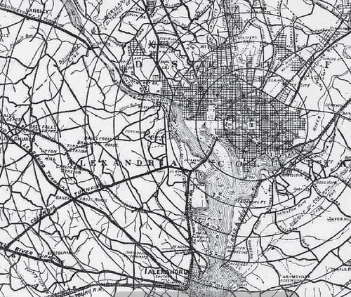
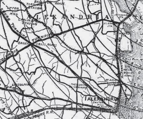
Detail showing Washington DC and then-Alexandria (not Arlington) County

Roberts Bicycle Map Washington DC and area 1896 - road quality
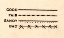
Indicators for quality of roads (for use by cyclists)

Roberts Bicycle Map Washington DC and area 1896 - Rides in VA
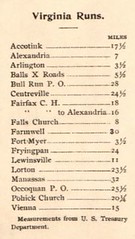
Runs (ie, rides) into Virginia from downtown Washington

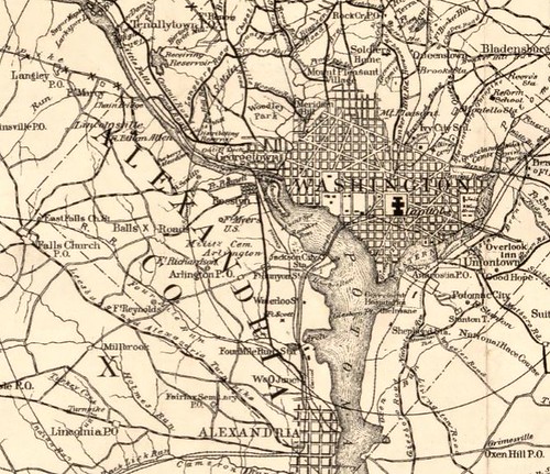
Distances are from the U.S. Treasury Department building and not the U.S. Capitol.

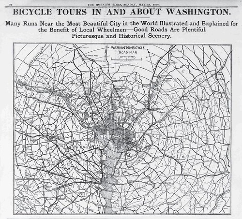
I found a similar, but not the same, map from 1896 published in the Washington Times that I blogged about.

Saturday, February 22, 2014

Capital Bikeshare Usage Visualized

Mobility Lab, a kind of think tank/advocacy organization in Arlington (Virginia), has this blog post that links to interactive displays of various kinds of usage of the Capital Bikeshare system based on 2013 statistics displayed on an aerial photograph of DC and northern Virginia. One of the amazing things about bikeshare systems is that they provide detailed statistics about cycling that have never been available before.

Washington DC Bicycle Map, 1896
PDF of map for cyclists in the Washington DC Morning Times, May 24, 1896

The above "Washington Bicycle Road Map (presented in a newspaper) is one I like very much since it covers so much of the DC region - it reminds me that at that time, the growing popularity of cycling was about leisure riding and a significant part of that for long rides into the countryside (which would now be suburbs, mostly). The city was only around a quarter of a million people after all. The map extends at least 12 miles out in all directions from the center of DC.

Saturday, March 5, 2011

1896 Map of Washington "Bicycle Tours"

Washington DC Bicycle Map, 1896

PDF of this newspaper page provides the best image quality and ability to zoom in. Given that this image is from microfilm of the original (that is, several times reformatted from the original paper item) the quality is pretty good. Not great, but good.

From the article below the map ~
There has never been a season when there was half as much travel on the flying wheel as there has been, is, and is going to continue to be this season.
and
Not a night passes but some gay party passes out for a run through the country. All routes are being tried and becoming better known, so that even the inexperienced, with the assistance of a map and a little information from a friend can make pleasant and health-giving trips into the open country.
The article goes on to provide descriptions of different possible excursions.

Bicycle Map, 1896 (Detail)

Above, somewhat more detailed view of the Northern Virginia part of the map; below, zooming in further

1896 Bicycle Map, Four Mile Run

Already in 1896 bicycle rentals were available ~
Escape from the heat and air of the city for a few hours a day is possible to every person who cares to learn to ride and can get the small amount necessary to hire a wheel - it is of course better to own one, but no longer absolutely necessary.

Wednesday, October 13, 2010

Capital Bikeshare Usage - Online Real Time Map

This map displays usage of Rideshare bikes in the DC area in real time.

Not so much usage yet, even in good weather, it seems. Still I have seen four or five being ridden, which seems pretty good since they are so new.

The Washington Post has this article on the topic.

Wednesday, August 11, 2010

NYTimes article on Google maps for Cyclists

Google leads, you pedal

While cyclists say all this bike-mapping software is handy for planning trips, most agree it is more useful as a Plan B than a Plan A, which should be just a normal, fold-up bike map. “I never would rely on it 100 percent,” said Mr. Maus of Portland, Ore. “Just as I wouldn’t only rely on car directions from GPS. It’s not as smart as a human being on the ground.”